The Settlement Period
1880 - 1913
Documents the origins of the community through to the beginning of the first world war.
.jpg)
Maps
.JPG)
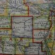
Pembina Municipality Section/Township/Range Map 2000 (1880)
Published in 2000, this map shows all of the rural schools in the Pembina Municipality.
PMA_2013_015121
Fond: Pembina Municipality
.jpg)
Physical & Cultural Geography of the McKenzie District MB (1880)
Dennis Windsor's Physical & Cultural History of the McKenzie District and 2-9W in Southern Manitoba.
PMA_2018_045631
Fond: Pembina Manitou Archive
Post Road and Early Trails - Manitoba (1880)
A map showing many of the early trails used by the first inhabitants of the Province.
PMA_2021_047444
Railroad Routing and Shipping Routes of Western Canada - ca 1909 (1880)
A detailed map of all rail lines in Western Canada including all siding along the routes. Downloading the map to your computer will allow you to view the map in detail.
PMA_2020_047072
.JPG)
Southern Manitoba and the Turtle Mountain Country by Rev L. O. Armstrong
Rev. L. O. Armstrong's diary of his journey from Emerson to the Turtle Mountains.
PMA_2025_079973
Fond: Pembina Manitou Archive